earthquakes

earthquakes

NOT IF, BUT WHEN

The Great Southern California ShakeOut scenario is based on a potential magnitude 7.8 earthquake on the southern San Andreas Fault near the Salton Sea. It’s not a matter of if an earthquake of this size will happen—but when. Chances are it will happen in your lifetime.

The U.S. Geological Survey studied the likely consequences of this potential earthquake, and produced the ShakeOut Earthquake Scenario. A magnitude 7.8 earthquake will last for almost two minutes, with the strongest shaking near the fault in the Coachella Valley, Inland Empire and Antelope Valley (Jones, et al., 2008).

An earthquake of this size could cause some 2,000 deaths, 50,000 injuries, $200 billion in damage and other losses, and severe, long-lasting disruption (Jones, et al., 2008). Click on the video below to watch how this scenario could unfold.

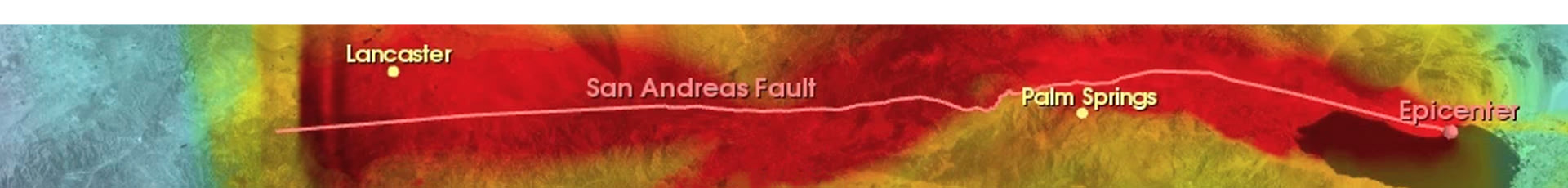
Fig. 1. Growth of a magnitude 7.8 earthquake on southernmost 200 mi of San Andreas Fault (USGS, 2008)

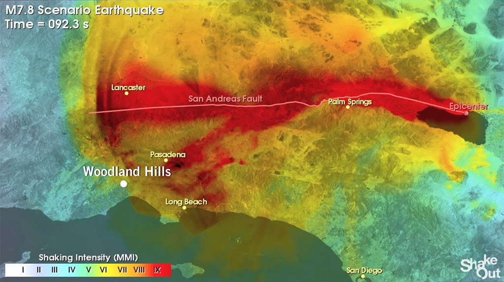
Fig. 2. Scenario of an earthquake 92 seconds after start in the Salton Sea, CA (Leggatt, 2015)

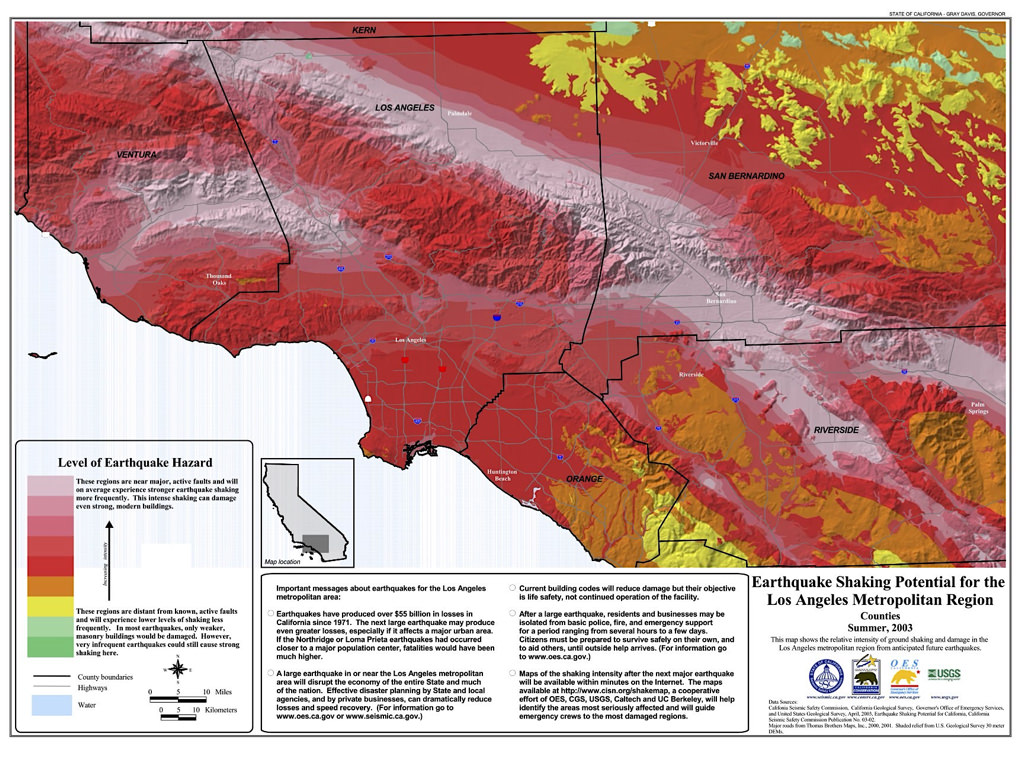
Figure 3. Level of earthquake hazard in Los Angeles Metropolitan Region (Seismic Safety Commission, 2003)

The following is an excerpt from The ShakeOut Scenario, Chapter 4, Physical Damages (pgs 94-95), by Keith Porter.

The major losses for this earthquake fall into four categories: building damages, non-structural damages, damage to lifelines and infrastructure, and fire losses. Within each category, the analysis found types of losses that are well understood—that have been seen in previous earthquakes and the vulnerabilities recognized but not removed— and types of losses that had been less obvious, where the type of failure is only recently understood or the extent of the problem is not yet fully recognized. The study also found numerous areas where mitigation conducted over the last few decades by state agencies, utilities and private owners, has greatly reduced the vulnerability. Because of these mitigation measures, the total financial impact of this earthquake is estimated to be “only” about $200 billion with approximately 1,800 fatalities. These are still big numbers.

The fault offset causes extensive damage to lifelines that cross the rupture: two interstate highways (I-15 and I-10) cross the fault and lose lanes as a result of the offset. Several oil and natural gas pipelines are also ruptured by the fault offset, as are several rail lines, aqueducts, and potable water pipelines. Shaking-related damage to highway bridges renders most freeways in Los Angeles, San Bernardino, and Riverside counties impassible at several locations, with some damages taking as long as 5-7 months to repair.

Electric power is lost throughout the study area immediately, and it is restored to 90% of those capable of receiving it within 3 days. Pipeline damage causes the loss of piped drinking water in much of the most strongly shaken areas (with MMI VIII+ shaking) for a week or more. Telecommunications are severely impacted as a result of heightened demand after the earthquake, and to a limited extent because of damage to telephone switching facilities and fiber-optic cables. Between 100,000 and 200,000 addresses lose phone and Internet service for between 2 and 5 days.

The earthquake causes the ignition of 1,600 fires. Owing in part to the loss of piped water for firefighting, 200 million sq ft of residential and commercial property valued at $40-100 billion is burnt. This is in addition to shaking-related property and direct income losses valued at approximately $60 billion. Five pre-Northridge highrise steel moment-frame buildings completely collapse, with approximately 5,000 people inside. Approximately 50 low- and midrise older reinforced concrete moment-frame buildings are hypothesized to collapse, most partially, as opposed to complete pancake- style collapse. These involve 800 people in completely collapsed concrete buildings and 7,000 in partially collapsed ones. Approximately 900 unreinforced masonry buildings are irreparably damaged.

Figure 4. Excerpt from The Shakeout Scenario (Jones et al, 2008) Click to download PDF; 18MB file size.

References

Jones, L. M., Bernknopf, R., Cox, D., Goltz, J., Hudnut, K., Mileti, D., Perry, S., Ponti, D., Porter, K., Reichle, M., Hope, S., Shoaf, K., Treiman, J., and Wein, A. (2008). The ShakeOut Scenario: U.S. Geological Survey Open-File Report 2008-1150 and California Geological Survey Preliminary Report 25. https://pubs.usgs.gov/of/2008/1150/of2008-1150.pdf

Leggatt, J. (2015). (Image based on ShakeOut scenario at 92 seconds from start.) [Image rendered by author.]


Seismic Safety Commission. (2003).
Earthquake Shaking Potential for the Los Angeles Metropolitan Region. [PDF]. https://ssc.ca.gov/wp-content/uploads/sites/9/2020/08/la_county_print.pdf

USGS. (2008).
Southern California ShakeOut. (Computer simulation of ground shaking from this scenario in a magnitude 7.8 earthquake, constructed in collaboration between the USGS and the Southern California Earthquake Center). https://escweb.wr.usgs.gov/content/learn/topics/shakingsimulations/shakeout/ShakeOut_mapview_hd.mp4

aboutWoodlandHills.com is not affiliated with, nor sanctioned by the City of Los Angeles or any other entity, public or private.
Information presented here is unverified, and is for entertainment and educational purposes only.

© 2024 John Leggatt