We kindly ask for your patience as we work on rebuilding this website. Your understanding is appreciated; thank you!
hazards
SUMMARY OF HAZARDS IN WOODLAND HILLS
(California Office of Emergency Services, n.d.).
| EARTHQUAKES | High: ground shaking (see earthquakes) |
| FLOODS | Low: Woodland Hills is outside a flood-hazard zone |
| LANDSLIDES | High: Parts of Woodland Hills are susceptible to landslides. |
| LIQUEFACTION | High: A large part of Woodland Hills is susceptible to liquefaction. |
| WILDFIRE | High: About half of Woodland Hills is inside a Very High Fire Hazard Severity Zone (VHFHSZ).* |
* As designated by the Los Angeles Fire Department, infra
FLOODS
Through the years, Woodland Hills has experienced—as have all other regions of California—flooding that have resulted in loss of life, caused tremendous damage to infrastructure and economies, and degraded native ecosystems (Department of Water Resources, 2013). But not all flooding is injurious; floods recharge water tables, replenish top soil, and support floodplains for endangered species (Department of Water Resources, 2013).
In general, flooding is caused by:
- alluvial flooding at the base of hillsides
- fast-moving flash floods caused by heavy rains
- slow-rise deep flooding on valley floors
- tsunamis in coastal areas
Flooding remains a risk in parts of Woodland Hills. The sedimentary nature of the clay and silt in low-lying parts Woodland Hills inhibits the absorption of rain water, though storm drains installed in recent years serve to mitigate that risk.
LIQUEFACTION
Liquefaction requires both strong shaking and a high ground-water table. Other factors that control liquefaction-induced ground failure are the extent, depth, density, and thickness of liquefiable materials, depth to ground water, rate of drainage, slope gradient, and intensity and duration of ground shaking (Department of Conservation, 1997).
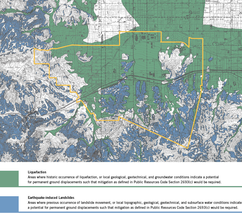
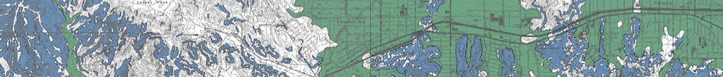
Figure 1. Areas where flooding and liquefaction may occur during a strong earthquake (Department of Conservation, 1998).

1810
Floods washed away adobe structures in Santa Ana and Anaheim.
1825
Heavy rains changed the course of the Los Angeles and Santa Ana rivers.
1861-62
The “Great Flood” drowned 200,000 cattle and swept homes, ranches, and orchards to sea, leaving floodwaters for 20 days. The rain created an inland sea in Orange County, lasting about three weeks with water standing 4 feet (1.2 m) deep up to 4 miles (6 km) from the river.
1884
Rains flooded Santa Ana and Orange, changing the course of the Santa Ana river.
1914
Heavy rains and flooding in LA Basin killed scores and caused $10M+ in damage.
1925
Heavy rains caused a major flood that altered the course of the Los Angeles and Santa Ana rivers.
1928
The newly constructed St. Francis dam at 35618 San Francisquito Canyon Rd, Santa Clarita (40 miles northwest of downtown Los Angeles) broke in March of that year, killing 431 people or more due to flooding.
1933-34
12” of rain caused mud and flood water to destroy 400+ homes in La Cañada and La Crescenta.
1938
Flooding caused by 10” of rain in five days inundated 250,000 acres in six counties, destroying 5,601 homes killed 115.
1965
Torrential rains caused widespread flooding, closing Highway 101 along the coast.
1978
Intense storms and inadequate drainage systems induced mudslides, killing 20 and causing $86 in damage across the region.
1980
Powerful storms destroyed homes, washed out bridges, and killed 29.
1983
Mudslides caused by heavy rains damaged 300 San Bernardino homes, and drowned 3,000 cattle.
1995
Heavy storms caused mudslides in Laguna Beach and Malibu, closing PCH.
2010
Torrents of water, mud, boulders and debris rushed out of steep canyons in Los Angeles, damaging cars and homes.
2018
A strong Pacific storm dropped record-breaking rain on Los Angeles evacuated by thousands of people over threats of debris flows and mudslides from wildfire burn areas.
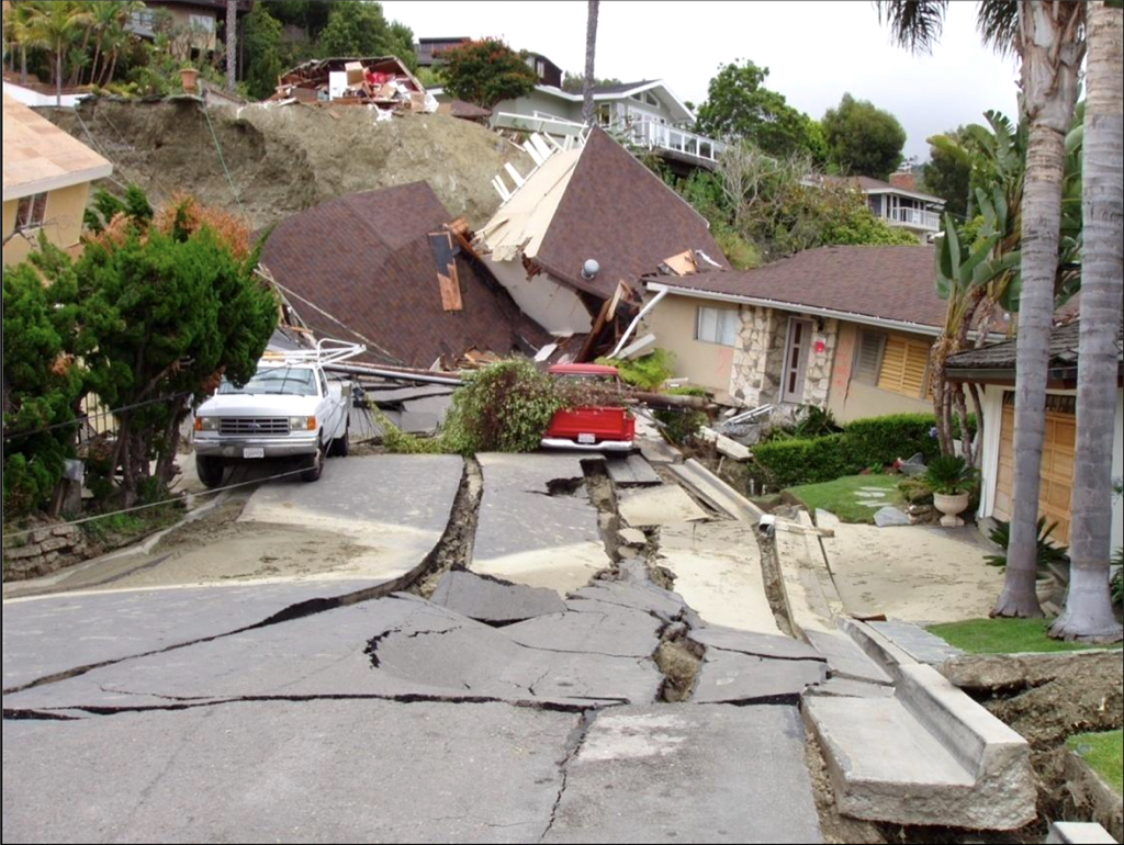
Fig. 9 Storm-induced landslide in Laguna Beach, CA (California Geological Survey, 2008).
LANDSLIDES
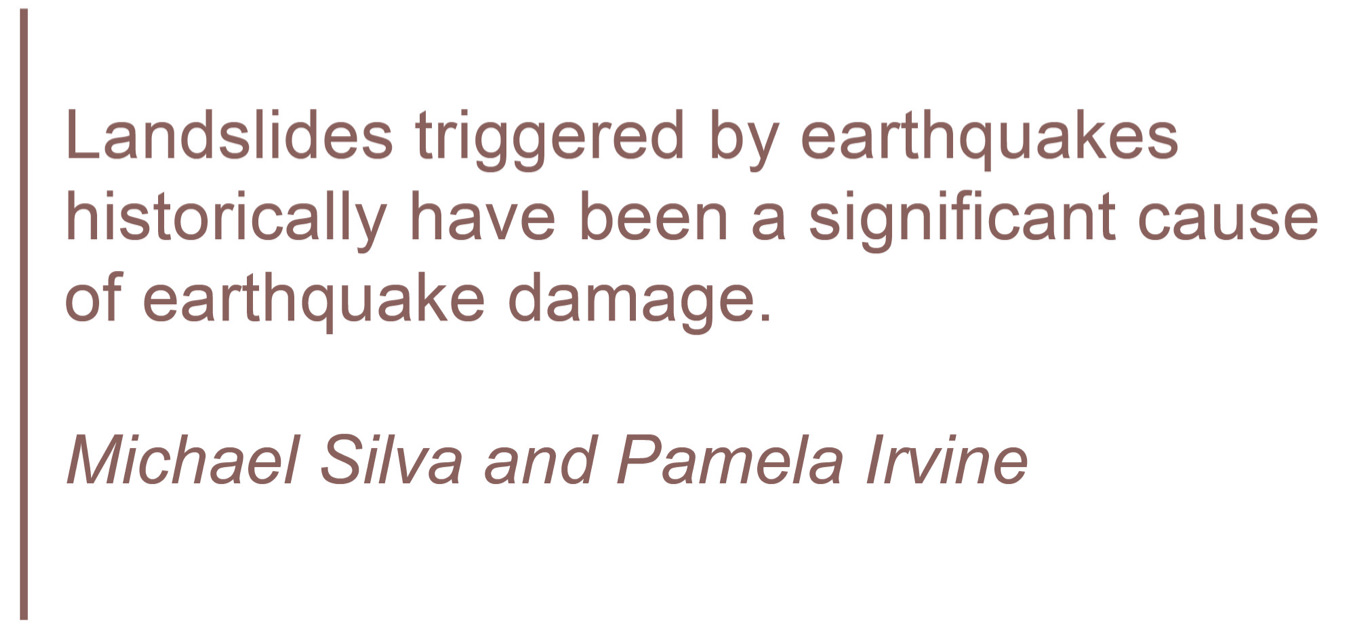
"Landslides triggered by earthquakes historically have been a significant cause of earthquake damage. In California, large earthquakes such as the 1971 San Fernando, 1989 Loma Prieta, and 1994 Northridge earthquakes triggered landslides that were responsible for destroying or damaging numerous structures, blocking major transportation corridors, and damaging life-line infrastructure.
Areas that are most susceptible to earthquake-induced landslides are steep slopes in poorly cemented or highly fractured rocks, areas underlain by loose, weak soils, and areas on or adjacent to existing landslide deposits. These geologic and terrain conditions exist in many parts of California, including numerous hillside areas that have already been developed or are likely to be developed in the future.
The opportunity for strong earthquake ground shaking is high in many parts of California because of the presence of numerous active faults. The combination of these factors constitutes a significant seismic hazard throughout much of California, including the hillside areas of the Canoga Park Quadrangle" (Silva & Irvine 2001). Click to download Earthquake-induced Landslide Evaluation Report (pg 27).
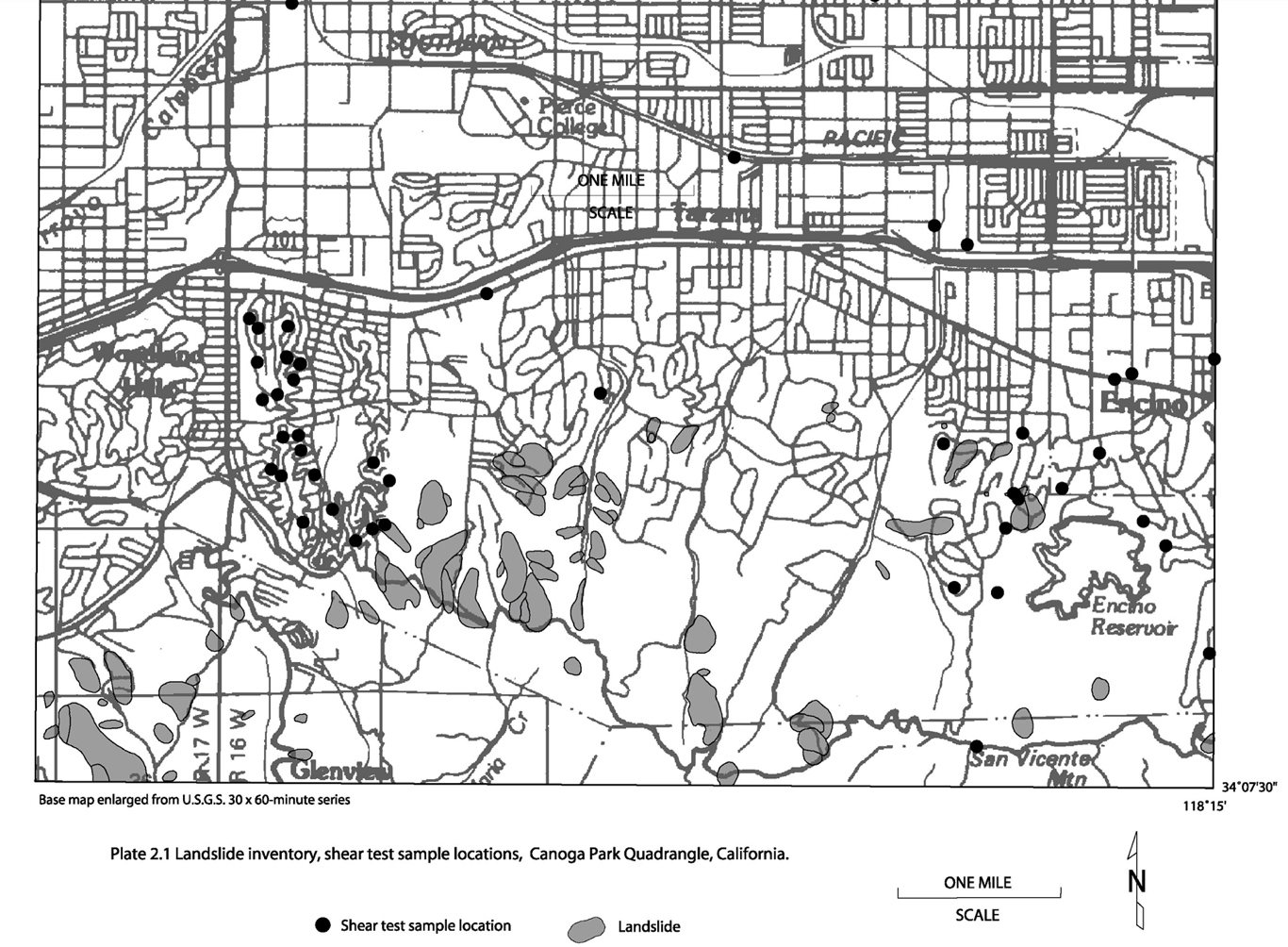
Figure 2. Inventory of known landslides in Woodland Hills (Petersen, M. D., Cramer, C. H., Faneros, G. A., Real, C. R., Reichle, M. S., 2001). Click to download Ground Shaking Evaluation Report (pg 47).

Figure 3. A consequence of heavy rains in Laguna Beach in 1998 (Snibbe, K. (2018).
On June 1, 1998, heavy rainfall triggered a massive landslide in the Bluebird Canyon area of Laguna Beach. This landslide occurred due to the saturation of soil, making it unstable on the steep slopes of the canyon. Approximately 350,000 cubic yards of earth slid down the canyon, engulfing several homes and properties.
Fortunately, there were no fatalities resulting from the landslide. However, the event caused extensive property damage, with many homes destroyed or severely damaged. The landslide prompted significant efforts to study the geological conditions of the area and implement measures to mitigate the risk of future landslides.
Efforts to stabilize the area and prevent future landslides included reinforcing slopes, improving drainage systems, and implementing stricter building regulations in landslide-prone areas.
The Laguna Beach landslide of 1998 serves as a reminder of the potential hazards associated with living in Woodland Hills, which are prone to landslides, and underscores the importance of proper planning, engineering, and land management practices to minimize the risk to communities in such areas.
WILDFIRE
California has a long and intense history with wildfire, with several in the past decade setting records for the largest, most deadly, and most destructive fires in the history of the United States as a whole. They have destroyed millions of acres of land, burned down hundreds of thousands of structures, and caused the deaths of humans, animals, and plants (Western Fire Chiefs Association, 2022).
Both the Los Angeles Fire Department and FEMA rate the wildfire hazard in Woodland Hills as "very high" and "relatively high" respectively. The following maps show where in Woodland Hills the wildfire hazard is greatest.
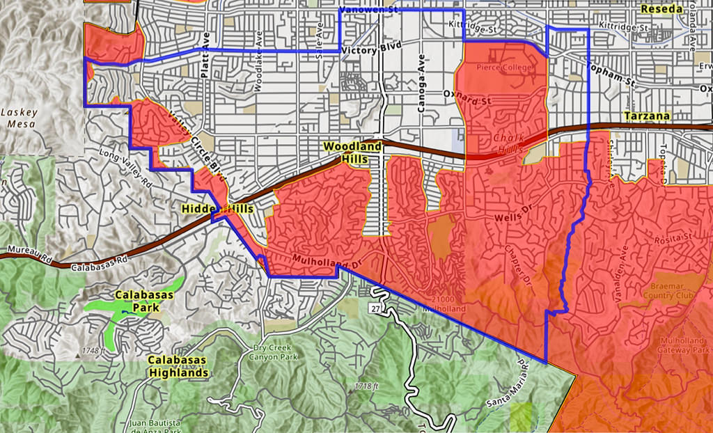
Figure 4. Areas in Woodland Hills that are located within LA Fire Department's Very High Fire Hazard Severity Zone, AKA VHFHSZ (Los Angeles Fire Department, (n.d.).
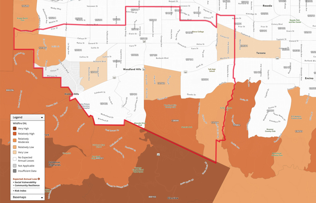
Figure 5. This map depicts the Expected Annual Loss (EAL) representing the average economic loss in dollars resulting from wildfires in Woodland Hills each year. It is calculated for wildfires and quantifies loss for relevant consequence types: buildings, people, and agriculture (FEMA, n.d.).
Discover how earthquake, flood, fire, and liquefaction hazards in Woodland Hills can affect you, and learn what steps will reduce your personal risk.
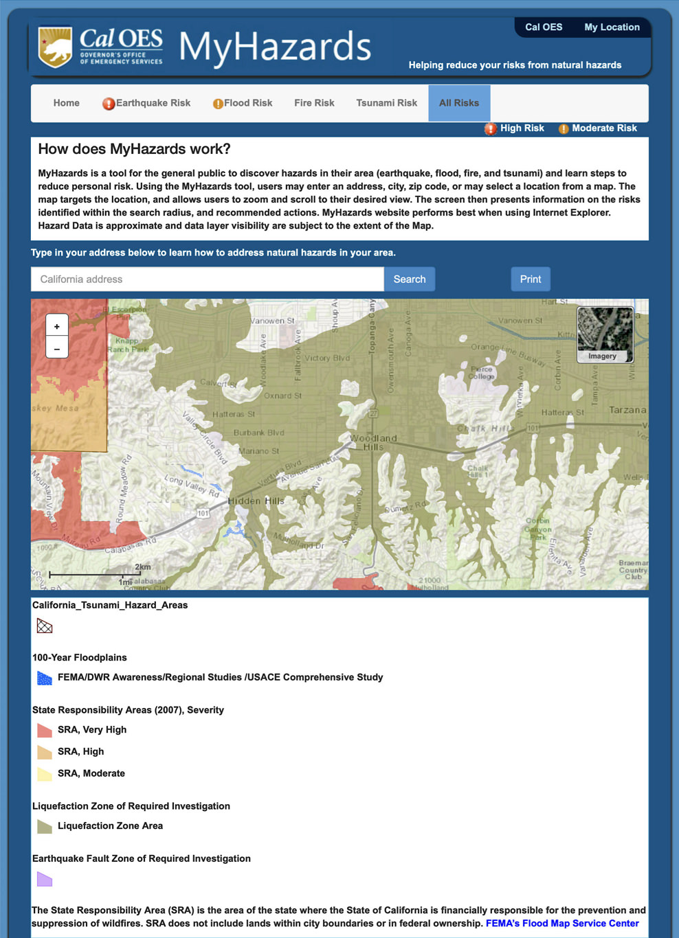
Figure 6. MyHazards is an interactive tool for the general public to discover hazards in their area (earthquake, flood, fire, and tsunami) and learn steps to reduce personal risk. (Governor’s Office of Emergency Services, n.d.). Click below to open MyHazards webpage.
The California Department of Forestry & Fire Protection released this comprehensive brochure in July 2023 explaining why and how to prepare yourself, family, and home for when (not if) a wildfire occurs in our area.
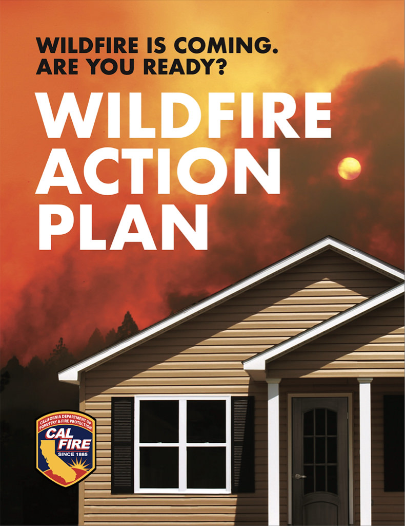
Figure 7. This guide shows why and how to create and maintain a defensible space around your home, and retrofit it with ignition-resistant or noncombustible materials. Click here to download the Wildfire Action Plan.
The Los Angeles Fire Department offers a free public notification system regarding significant Fire Department incidents occurring in or affecting the City of Los Angeles. The system, called LAFD ALERT, helps you stay safe and well informed when specific emergencies occur in areas of interest to you in the city.
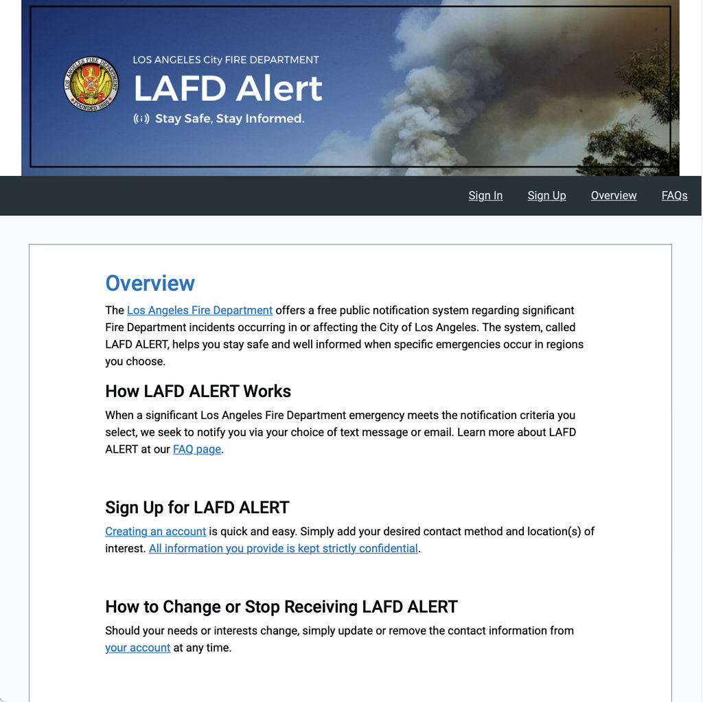
Figure 8. Areas in Woodland Hills that are located within LA Fire Department's Very High Fire Hazard Severity Zone, AKA VHFHSZ (Los Angeles Fire Department, n.d.).
References
California Department of Forestry & Fire Protection. (2023, July 19). Wildfire Action Plan. Wildfire is Coming. Are you ready? http://www.readyforwildfire.org/wp-content/uploads/Wildfire_Action_Plan_071923-Digital.pdf
California Geological Survey. (2008). Guidelines for Evaluating and Mitigating Seismic Hazards in California. https://www.conservation.ca.gov/cgs/Documents/Publications/Special-Publications/SP_117a.pdf
California Nevada River Forecast Center. (2010). Heavy Precipitation Event-California and Nevada. [General summary]. https://www.cnrfc.noaa.gov/storm_summaries/dec2010storms.php
Department of Water Resources. (2013). History of California Flooding. [pdf]. https://www.water.ca.gov/sfmp/resources/PRD_AttachC_History_4-3-13.pdf
Department of Water Resources. (n.d.). History of California Flooding. https://water.ca.gov/About/History
Department of Conservation. (1998). Seismic Hazard Zone Report for the Canoga Park 7.5-minute Quadrangle, Los Angeles County, California. [pdf]. https://gmw.consrv.ca.gov/shmp/download/quad/CANOGA_PARK/reports/canpk_eval.pdf [archived]
Floods in California. (n.d.). In Wikipedia. https://en.wikipedia.org/wiki/Floods_in_California
Governor’s Office of Emergency Services. (n.d.). MyHazards: Discover earthquake, flood, fire, and tsunami hazards in your area; learn steps to reduce personal risk. https://myhazards.caloes.ca.gov
Hammond, A., & Hazlewood, M. (1972). It Never Rains In Southern California [Recorded by Albert Hammond]. Epic Records. (1972). [Audio file]. Retrieved from https://hitparade.ch/song/Albert-Hammond/It-Never-Rains-In-Southern-California-264
Leggatt, J. (2015). [Image based on seismic hazards map. Image rendered by author.]
Los Angeles Fire Department. (n.d.). Fire Zone Map. https://www.lafd.org/fire-prevention/brush/fire-zone/fire-zone-map
National Academies of Sciences, Engineering, and Medicine. (2013). Levees and the National Flood Insurance Program: Improving Policies and Practices. Washington, DC: The National Academies Press. https://doi.org/10.17226/18309
Petersen, M. D., Cramer, C. H., Faneros, G. A., Real, C. R., Reichle, M. S. (2001). Section 3. Ground Shaking Evaluation Report: Potential Ground Shaking in the Canoga Park 7.5-Minute Quadrangle, Los Angeles County, California. [pdf]. (This report appears on pg 47 of Seismic Hazard Zone Report for the Canoga Park 7.5 Minute Quadrangle, Los Angeles County, California, infra). California Department of Conservation Division of Mines and Geology.
Silva, M. A. & Irvine, P. J. (2001). Section 2 Earthquake-induced Landslide Evaluation Report. [pdf]. (This report appears on pg 27 of Seismic Hazard Zone Report for the Canoga Park 7.5 Minute Quadrangle, Los Angeles County, California, infra). California Department of Conservation Division of Mines and Geology.
Snibbe, K. (2018, February 23). How Laguna Beach’s history with devastating landslides has made it one of the most alert cities in the United States. The Orange County Register. https://www.ocregister.com/2018/02/23/how-laguna-beachs-history-with-devastating-landslides-has-made-it-one-of-the-most-alert-cities-in-the-united-states/
Western Fire Chiefs Association. (2022, November 17). History of California Wildfires. WFCA. https://wfca.com/wildfire-articles/history-of-california-wildfires/